| Geothermal energy prediction technique - Page 4 | |||
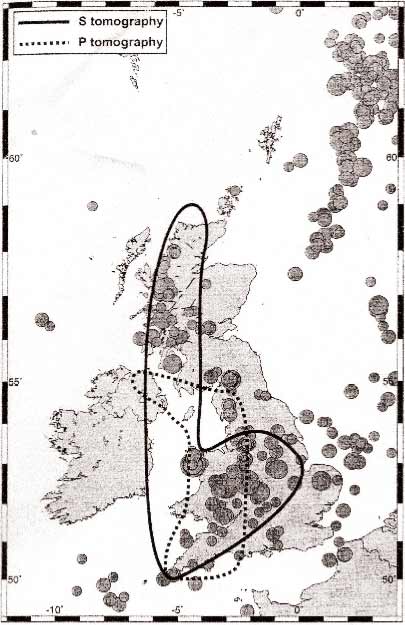
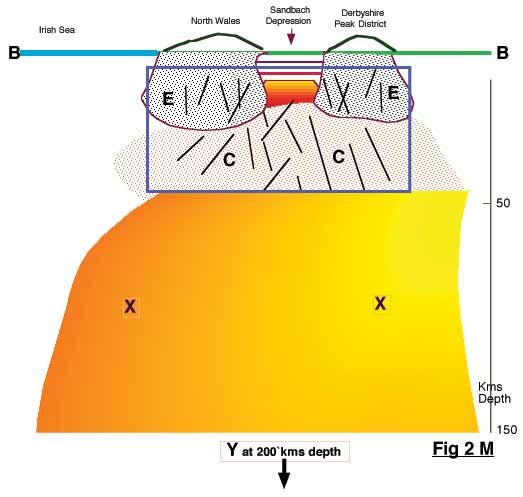
Deep Geothermal Implications in the United Kingdom (4)Since publishing Geothermal Implications in The United Kingdom (1, 2 and 3) new information has become available to me, from a paper by Dr Bott et.al. This paper was published in, The Journal of the Geological Society London. Vol.161, 2004, pp 19-29. Which refers to an underlying low-density hotspot in upper mantle. This he defined by using a technique called Tomograpy, which is also used in medical scanners, very successfully. This discovered heat source seems to bear out my ideas in my preceding paper, Geothermal Implications in The United Kingdom (1, 2 and 3). In Dr Bott's paper he refers to the heat source as magma. I have calculated that the magma described occupies a 12,000,000 Cubic Kilometre block of magma. An area of magma this size must contain an enormous amount of energy, just waiting to be tapped. The next step in this riddle for the transport of heat through the intervening area, shown in my diagram (fig. 2M) as a box 'C'. My next clue came from an old colleague a Dr R.R.Dibble in New Zealand, while discussing his project on the active volcano Erebus in the Antarctica. I questioned him on the mechanism for feeding the Lava Lake in its crater, which has been permanent for many years. He described a volcanic pipe as the link from the Magma up to this Lava Lake, transmitting sufficient heat to support this Lake. This volcanic pipe is well inside what is normally defined as the Antarctic plate, approximately as far from the edge of the so-called plate, as we are from the Atlantic ridge. If this is so, then why not a pipe or pipes or even faults lying under our four main volcanic centres in the United Kingdom not necessarily active in the same sense, but terminating in several geothermal aquifers underground (fig. 2M) in box 'C'. It need not be a defined pipe, but a number of fractures could lead to sufficient supply of heat, required for sustaining a good ongoing supply. I believe that here is the engine or engines of our reservoir, drawing energy from the underlying magma block feeding the heat necessary to supply energy for the aquifers underground. This could also be the source which is still leaking into our various spas and outlets on the very surface of our country. I have, complete with maps produced earlier in my paper, another suggested solution to the problem in our volcanic centres, which I feel was frowned upon. Yet they state: as yet there is no logical explanation. Now, what I am suggesting as a possible explanation, in conjunction with Dr Bott's large magma pool, gives me the roots for explaining my earlier thinking, as a very possible solution to the clusters in our surface volcanic centres. I am offering a possible solution to this phenomenon. I know that from my own experience when, after many years of work, I produced a paper entitled "Geothermal Ground Noise in the Taupo region of New Zealand". I travelled to the I.U.G.G. conference in Zurich and presented this paper. It was a resounding success, which opened doors for me. It was not necessarily totally accepted. But J.G.R. in the USA asked for my permission to publish it, which they did. It was a new concept and tool to aid in the identification of Geothermal aquifers, which it did. This was a lesson to me that made me realise that we only move ahead by not tying ourselves down to theories completely, but using them as a further impetus to do more, or try to get at the proven truth. What I am now suggesting concerning "Geothermal Implications in the United Kingdom (1, 2 and 3)" has met with little resistance so far, except with those who prefer to stick with the status quo. I refer to this status quotient <grin> as the "2000 footers". This refers to shallow hot water whose source they do not seem to understand. Some people think, after its observed presence since Roman times, that its presence and longevity of producing hot water begs for an explanation. I believe, by Dr Bott's Tomography paper, he has taken us a step closer to this deep hidden source which, up until now, was undetected. While we understand quite a lot about the the first 2000 feet of our surface, or, as some prefer to call it, "crust", we apparently do not know a lot about the area below that level. In fact some seem to treat it as an homogeneous area - possiby because of the lack of deeper holes, or seismic activity, apart from an oil hole drilled at Seal Sands. This hole was drilled to a depth of 13,370 feet by Monsanto but the information surrounding this hole appears to be unobtainable. The recent Geothermal bore hole at Eastgate in Weardale, 3265 feet deep, demonstrates the fruitlessness of the 1980's government survey, which failed to include it on their maps. The government survey, carried out principally in the 1980's, produced absolutely no evidence of this resource; yet it is considered to be a very important resource now. Their maps showed this area as a complete blank. In fact, although they mentioned Southampton, they did not show it on their general map of shallow geothermal aquifers. Extract from Weardale Geothermal project. Geothermal energy is derived from the heat contained within the Earth's crust, which increases in temperature the deeper you go. In certain areas, the temperature near the surface is hot enough to make extraction of this heat energy practical. Provided energy is not extracted faster than it is replenished by deeper, hotter sources, geothermal can be considered a renewable energy source. The Weardale project makes a very important point. It states that the energy is extracted from deeper hotter sources. This makes the point, which seems to escape most people: that these near-surface heat sources must have a sustaining replenishing source, until such time as the supplying source cools down, so it can no longer be able to sustain the input of heat. Even if we try to consider this, it is a long way off, as is that large block of magma described by Dr Bott in his paper. This takes us to Dr. Bott's magmatic heat source from 50 down to 200 kilometres deep, which is feeding up into these shallower aquifers (fig. 3M), which gives an idea of the scenario of what is probably occurring under the United Kingdom. The heat supply from the magma outlined by Dr. Bott et al, in which he stated: " British earthquakes concentrate on a similar north-south belt, with the strongest events in the west. We suggest that the earthquakes result from the continuing tectonics associated with the hot upper mantle, the uplift it causes, and the weakened crust. The underlying low-density region gives rise to tensional loading stress in all directions and bending stresses are associated with the upper crustal flexing accompanying uplift. These large stresses supplement NW-SE regional compression. Available earthquake mechanisms are approximately consistent with this stress environment." So it appears we can have the situation I have described for some time in the previous three sections:- Geothermal Implications in The United Kingdom (1) Geothermal Implications in The United Kingdom (2) Geothermal Implications in The United Kingdom (3) This section is reprinted from Dr Bott et al., paper published in: "The Journal of the Geological Society London, Vol.161, 2004, pp 19-29". Goes et al. (2000) used these velocity distributions independently to estimate anomalous temperatures in the upper mantle beneath Europe between 50 and 200 km depth. The resulting temperature anomalies can be interpreted in terms of anomalous densities using the volume coefficient of thermal expansion, such that a temperature anomaly of +100ºC corresponds to a density anomaly of about -10 kg m -3 . The interpretation based on P shows a north-south belt of anomalously high temperature beneath Wales, western England and part of the Irish sea (Fig 1). The estimated high temperatures at 100 km depth ranges between 1200ºC and above 1300ºC and relates to a level of 1000-1200ºC in the adjacent regions. The interpretation based on S shows a north-south linear hot zone extending eastwards across the English Midlands, (Fig 1) with temperatures at 199 km depth of 1300-1400ºC above a regional background level of about 1200ºC . Although the interpretations based on P and S differ substantially because of the problems of resolution on this scale and other uncertainties, nevertheless their partial coincidence (Fig 1) gives credence to the presence of an expectedly high-temperature zone in the upper most mantle underlying the strongly uplifted western part of the mainland and the adjacent Irish sea. In contrast to the more permanent underplating, a thermal anomaly decays with time. We estimate that a uniform thermal anomaly between the depths of 30 and over 100 km would probably lose 30 and 70% of its original excess heat to the surface over 60 ma, depending on the depth distribution of the excess temperature and role of rising fluids. The postulated high-temperature zone approximately corresponds to the mainland belt of British earthquakes (Fig 1), which shows a similar asymmetry to the pattern of uplift. Both uplift and seismicity of mainland Britain may thus be related to the inferred hot and low-density uppermost mantle beneath, with a temperature of around 1250 ±100ºC at 100 km depth and about 150ºC hotter than the surrounding area. The temperature may be hot enough for partial fusion. Fig.1. British earthquake epicentres with magnitude 2,5 ML or greater, January 1979 - November 2002 (British Earthquake Database), shown with approximate outlines of hot upper-mantle regions inferred from S-wave tomography by Goes et al. (2000). British Geological Survey ©NERC, 2003. Dr Bott's paper was published in: "The Journal of the Geological Society London, Vol.161, 2004, pp 19-29", in which he refers to an underlying low-density hotspot in our upper mantle. This low-density hotspot he defined by using a technique called Tomography. Tomography is a very successful technique used in medical scanners. It records cross sections of the internal body. A complete three dimensional picture is made up from the scans, which is then used to aid a surgeon performing an operation. Magma is defined as material at 670 degrees centigrade or higher. (Below this temperature it becomes lava). I have calculated that the area described as magma by Dr Bott occupies a 12,000,000 Cubic Kilometre block. An area of magma this size must contain an enormous amount of energy, just waiting to be tapped. His paper states that, at a depth of 100 Kms beneath Wales and western England and up to Northern Ireland, temperatures are between 1200°C and 1300°C. The next step in this riddle, for the transport of heat through the intervening area, shown in my diagrams outlined by a box designated 'C' (fig. 2M and 3M), came from a discussion with an old colleague of mine, a Dr R. R. Dibble in New Zealand. Dibble is involved in a project on the active volcano Erebus in the Antarctica. I questioned him on the mechanism for feeding the Lava Lake in its crater, which has been a permanent feature for many years on that volcano. He described a volcanic pipe as the link from the Magma up to this Lava Lake, which is transmitting sufficient heat to support it in its molten state. This volcanic pipe is well inside what is normally defined as the Antarctic plate, approximately as far from the edge of the so-called plate, as we are from the Atlantic ridge which is one edge of our plate. If this is so, then why not a pipe or pipes (or even faults) lying under our four main volcanic centres in the United Kingdom? Not necessarily "active" in the same sense, but terminating in several geothermal aquifers underground (fig. 2 M) in box 'C'. It need not be a defined pipe, but a number of fractures could lead to sufficient supply of heat, required for sustaining a good ongoing supply of heat. I believe that there is a long term reservoir of high energy, ready to be tapped. This could also be the source of heat which is still leaking into our various spas and outlets on the very surface of our country. Hot fluids from these centres can be transmitted to sites, outside these volcanic centres, horizontaly through layers of permeable material, as for Southampton, Droitwich and now Weardale. Lavas can produce tubes up to 30 metres in width, which can be up to tens of kilometres in length, in any direction. That would certainly be a large cavity, or pipe as the case may be. But, of course, there could also be many smaller ones. So, I suggest that my (fig 2M) with a depth of 50 Kms., to the top of Dr Botts magma block, which he has outlined, could contain many of this kind of conduits or faults, that can carry a lot of heat to produce several geothermal hot aquifers, at a much shallower depth. The rising heat may fuel, in a small way, our own underground shallow hot water aquifers, of which several are being exploited at this time. So, within the confines of our Western volcanic areas defined in (fig 3), we do have a mechanism to feed heat into our underground fractures, pipes or lava tubes. | |||
|
| |||
| Area surrounded by the blue line is the main area for contemplation for deep geothermal drilling. It is also an area that we have least knowledge of. The areas 'X' and 'Y' defined by Dr Bott's tomographic study of that area. The fractures depicted in areas 'E' are fractures contained in the old volcanic roots. These are suggested by my own suggestion that the many small earthquakes depicted in the B.G.S. report "UK earthquake Monitoring 2005/ 6 17th annual report page 21. This is also discussed and presented in my previous report On the " Geothermal Implications of the United Kingdom" I feel it can be confidently predicted that the area 'C' contains fractures, that can carry heat in several forms upwards into possible high temperature geothermal aquifers. There is also the possibility of some form of volcanic pipes of varying sizes, which we find feeding some active volcano's in various parts of the world occurring in this area. It is also possible that this area I call 'C' can be seismically quiet, unlike the very solid volcanics in the section 'E'. . The area I call the Sandbach depression, which covers many square kilometres of surface, is a very likely contender for deep drilling. Areas with Geothermal hot aquifers seem not to support earthquake activity, and in all cases I discovered they where aseismic. Which is what I would expect the 'C' area to be. Geothermal Ground Noise should be present in this area, if we can detect it by seismic means. There are six areas I have outlined in ( fig 6 ) Geothermal Implications in The United Kingdom (1). where exploration could be successful. Consequently, it appears we can have the situation I have described for some time in the previous three sections:- Geothermal Implications in The United Kingdom (1) | |||
| Fig. 3M
| ||
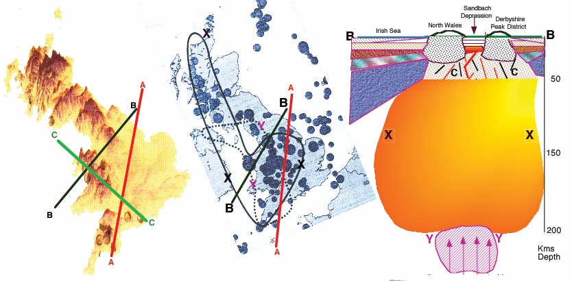
| Monitoring 2006/2007 Page 22 Using the surface Volcanic expressions to the west or left of the line A & B. The coincidence of Drs. Bott's paper defining where the magmas are located down to 200Km. With all this seismic activity there have to be points where this is at a reasonable depth to drill for. Southampton, Bath, Droitwich, Harrogate and Weargate all appear to draw heat from this underground magma body. | British earthquake epicentres with magnitude 5ML or greater, January1979-November 2002 (British Earthquake Database), shown with approximate outlines of hot upper-mantle regions inferred from S-wave and P-wave tomography by Dr Bott et al. (2000) British Geological Survey Copyright NERC. 2003. | Suggested cross-sections derived from the two maps depicted on this page. The inferred area around "C" is our zone of high interest, which could contain several geothermal aquifers. The "Y" area indicated, is the high temperature input for the "X" area defined in Dr Bott's paper where he suggests temperatures from 670ºC. |
Send this page address - CLICK HERE - to a friend !