APPENDIX 4.
Published in
The American Geophysical Union's
Journal of Geophysical Research
Vol.73 August 15, 1968, No 16,
pp. 5377 to 5383.
NOTE.
THE AREA "BROADLANDS" WAS DEFINED BY
THIS SURVEY BEFORE ANY DRILLING TOOK PLACE, OUTLINED THE
DRILLING TARGET WHICH IS NOW A PRODUCTION AREA.
JOURNAL OF GEOPHYSICAL RESEARCH
VOL. 73, No. 16, AUGUST 15, 1968
Geothermal Ground Noise Amplitude and Frequency
Spectra in the New Zealand Volcanic Region
G. R. T. CLACY
( Institute de Geofisica, Torre de Ciencias, Cudad
Universitaria, Mexico. Also a consultant to Geotech, Dallas,
Texas. 1968-1971)
Geophysics Division, D.SJ.R., Wellington, New Zealand
A survey made with a portable slow-motion tape seismograph
of the Rotorua, Taupo volcanic region, showed that areas of
continuous high seismic noise and low dominant frequencies
were found in conjunction with aquifers.
INTRODUCTION
Owing to ground unrest in the Rotorua, Taupo, volcanic
region of New Zealand, survey work by various geophysical
methods has been hampered. A constant high seismic noise
level is encountered for most of the region. It was decided
to record this phenomenon. The instrument chosen was a
continuous direct-recording tape seismograph and Willmore
seismometer, which was described by Dibble [1964].
The method of measurement and the final plotting on maps
were devised by the author as the survey progressed, and the
total amplitude from 1 to 20 cps was plotted and contoured.
The dominant continuous frequency in the same frequency
range is described below.

Fig. 1. Over-all. total `noise amplitude
from 1 to 20 cps relative to a predetermined level.
Recording stations covering the Taupo volcanic region are
shown by the solid dots. 5378 G. R. T. CLACY
Precautions were taken to ensure that any sudden increases
in ground noise would be known and could be calculated
for.
DISCUSSION OF RESULTS
Recordings made during 1966 are indicated by dots on Figure
1. This map also shows that the over-all contours of
relative total groundnoise amplitudes, which are derived
from the continuous frequency bands 1-20 cps, are
logarithmic in scale and do not include manmade noise,
winds, ocean microseisms, or other periodic surface seismic
noise. The exclusion of noises is simple, because they are
readily spotted during the frequency analysis process and
because periods free of these spurious noises occur during
the night.
On the amplitude basis in Figure 1, it is easy to see areas
of noise and quiet and to find areas that require more
detailed survey. The Broadlands area was surveyed with
approximately 914.4 metres station separation. From this
survey, maps (Figures 2 and 3) were prepared. Figure 2 shows
fairly well defined high noise areas, and Figure 3 shows the
frequency distribution over the same area. It will be
noticed how the lower-frequency dominant continuous noise
moves up in frequency away from the high noise source.
A further interesting survey with bore 2 running was made
using the same survey stations in the Broadland area. The
records of this survey are plotted in Figures 4 and 5. As
one would expect, the total noise in the immediate area of
the bore increased, as did the dominant frequency. The
hitherto high-noise area of 6.5 increased only slightly,
however, and the seismic noise from the bore decreased more
rapidly toward this point. The dominant frequency pattern
emerged around the bore
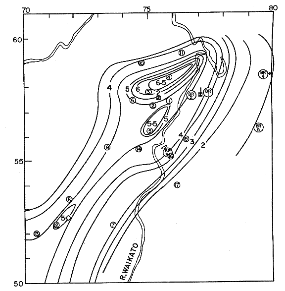
Fig. 2. Over-all total noise
amplitude from 1 to 20 cps. The recording stations are shown
by the open circles, and the bores are shown by the solid
squares. Bores 1 and 2 closed in the Broadlands geothermal
area during the survey.
GEOTHERMAL NOISE AMPLITUDE AND FREQUENCY
SPECTRA 5379
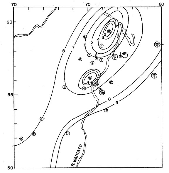
Fig. 3. First dominant frequency from 1 to
10 cps. The recording stations are shown by the open
circles, and the bores are shown by the closed squares.
These contours apply to the same conditions as Figure 2.
but at higher frequency; it emerged from the bore area with
increasing frequency away from the noise source.
In the Maroa region, which is a fairly young volcanic centre
(Figure 6) with no obvious surface activity, a high seismic
noise pattern is present but no frequency analysis has yet
been made for this region.
The Waiotapu Thompson area shows an interesting noise
pattern (Figure 7): small and a little more complex. The
frequency spectrum (not shown) is quite complex, but the
2-cps frequency does emerge in the high-noise area. Obvious
surface activity occurs where the bores are. These bores are
not, however, good producers, so that the aquifer system is
perhaps located where the high noise, low frequency
appears.
CONCLUSIONS
The seismic-noise pattern of a geothermal region is probably
a useful method for determining an underground
steamproducing aquifer because the water contact with heat
appears to produce a useful seismic noise pattern that can
be plotted to determine the possible extent of an aquifer.
In Figure 8 the emergence of 2 cps as the dominant frequency
is probably due to the attenuation of the higher
frequencies. As the travel paths improve, the higher
frequencies become the dominant ones. The direction of the
aquifer depends on the rate of emergence of the higher
frequencies, as does the size of the aquifer. The mechanism
in Figure 8 suggests water supported by gas vapor, as in the
Liedenfrost effect. This condition could account for the
2-cps emission,
5380 G. R. T. CLACY
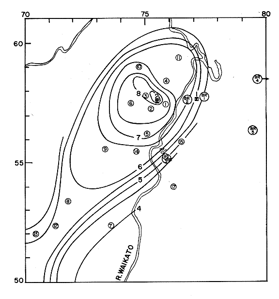
Fig. 4. Over-all total noise
amplitude from 1 to 20 cps relative to a predetermined
level. Recording stations are shown by the open circles, and
bores are shown by the closed squares. Bore 2 was producing
steam. Bore 1 closed in the Broadlands geothermal area
during survey.
GEOTHERMAL NOISE AMPLITUDE AND FREQUENCY
SPECTRA 5381

Fig. 5. First dominant frequency from 1 to
10 cps. These contours apply to the same conditions as
Figure 4.
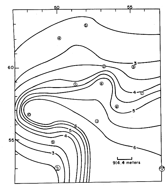
Fig. 6. Over-all total noise amplitude from
1 to 20 cps relative to predetermined level.
Recording stations are shown by the open circles in the
Moroa Geothermal region.
GEOTHERMAL NOISE AMPLITUDE AND FREQUENCY
SPECTRA 5383
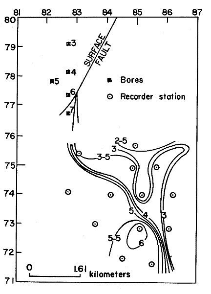
Fig. 7. Over-all total noise amplitude from
1 to 20 cps relative to a predetermined level. Recording
stations are shown by the open circles in the
Thompson-Waiotapu geothermal region. The bores are shown by
the closed squares.
with water in contact with lower heat around the perimeter
giving the higher-frequency dominances. The cooling and
regeneration of heat source will give rise to many other
frequencies. I think that a multiple noise generator is
necessary because of the many discrete narrow-band frequency
dominances recorded at one time, though all frequency
dominances are low in the centre of a good aquifer system.
Therefore, high-noise and low-frequency dominance indicates
a good aquifer.
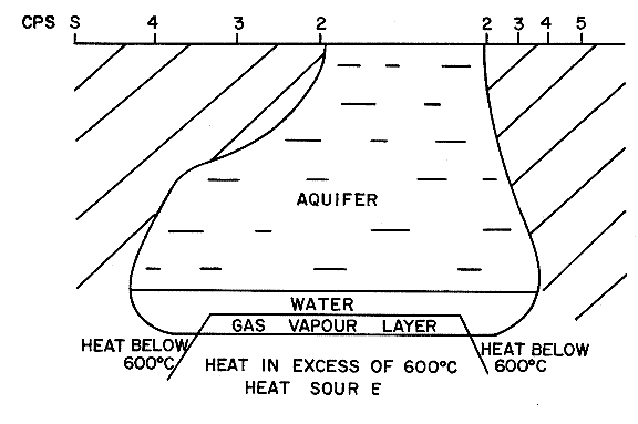
Fig. 8. Proposed model of geothermal
groundnoise source indicating zone of high-frequency
attenuation.
Acknowledgments.
I thank Dr. T. Hatherton and Mr. C. J. Banwell for their
advice and encouragement and Mr. D. J. Dickinson for his
field assistance.
REFERENCES
Dibble, R. R., A portable slow motion tape recorder for
geophysical purposes, New Zealand J. Geol. Geophys., 7(3),
445, 1964.
(Received November 9, 1967;
revised January 22, 1968)
Go to
Download page
for seismic audio files and
discussion by G.R.T. Clacy
Return to main
page
|