| Geothermal energy prediction technique - Page 3
| |||||
| |||||
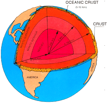
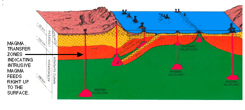
| 23 / 07 / 2007 Comments on a Geothermal study carried out for D.O.E. I have just finished studying the government report entitled "GEOTHERMAL AQUIFERS Department of Energy R & D Programme 1976-1986". The main study was terminated at around 2000 feet below sea level. The geothermal bore at Southampton is operating at a depth of 1.7 Kms (0,588 of a mile). From then on they have made projections which appear only to assume that the depth beyond this level be homogeneous. Obviously this cannot be so when you consider the volcanic extrusions which have broken surface in this country, as you can see by the answers I have received from the top government sources. These being Lord Truscott and Malcom Wicks. They appear to have written off Geothermal for the production of electricity after only "scratching the surface" (literally). The people who carried out the work for this study are in the Nuclear Industry and the Oil Industry, who (in my opinion) do not even understand what the aims are - only their own selfish dominance of the energy business. I found this was so in the USA. The Oil industry were buying up all the leasable land for geothermal back in the 1970s, usually after following our surveys. A lot of opposition came from the Oil and Nuclear Industries there. At that time I was carrying out surveys across the Western States of that country. The USA has now realised that these earlier efforts were dogged by the oil and nuclear people and has set up a government department to push Geothermal ahead. It is well to understand that, in the USA, more especially in the West, land leases are half owned by the government and half by private enterprise. This should allow the USA government to proceed in these areas, now they have formed a full time Geothermal department . I feel that, in this country, there should have been an assembled team with only one goal in mind: Geothermal. At least it should have been carried out by some people from the Geothermal Industry of which there were many available at that time throughout the world. The aforementioned report does not appear to have had a properly dedicated team with knowledge of Volcanic and Geothermal matters. We were all taught in school using diagrams shown in the attached (figure 10, below), that one of the features is the intrusive magmas reaching up through the crust. The cross sections represent the Earth's very hot centre. This hot mantle and nucleus, in conjunction with intrusive magma's activity that reach up to and just below the surface of the Earth, indicates that it is very feasible to have one or more of these magmatic feeds underlying our present surficial volcanic areas. Its longevity is proven because of the length of time that the surface hot springs have been producing hot waters - at least since the Romans were here, and more than likely long before. The heat that is being lost is at the same time being replaced by one or more volcanic intrusive magmas reaching up through our crust. Apparently, Southampton has been utilising hot water from a shallow hole right under that city for at least 20 years. The GEOTHERMAL AQUIFERS report I have referred to has never considered its source for the heat regeneration. This is what I intend to do and I possibly have the skill to do just this. I am carrying on my own personal studies of this massive energy source right under our country. Interestingly enough, the map in the final stages of the D.O.E. report does not even include Southampton. This report seems to rely a lot on conjecture and homogeneous modelling, but no one has drilled further than 2000ft in this report. However, records show that Monsanto drilled a 13,670 ft deep hole at Seal Sands, Teesside. This hole was probably drilled with only oil in mind. The question has to be asked if, when such a wonderful commodity as Geothermal power was the quest, why did the people involved in this project only drill up to 2000 ft boreholes? I certainly can ask many more questions of the report as above, which does not seem to be very knowledgeable of Geothermal and Volcanic matters. | |||||
| Fig.10
This is how the earth is represented Internationally by academics to pupils.
Fig 10 | |||||
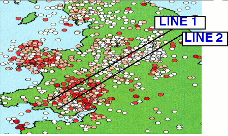
| Fig 11 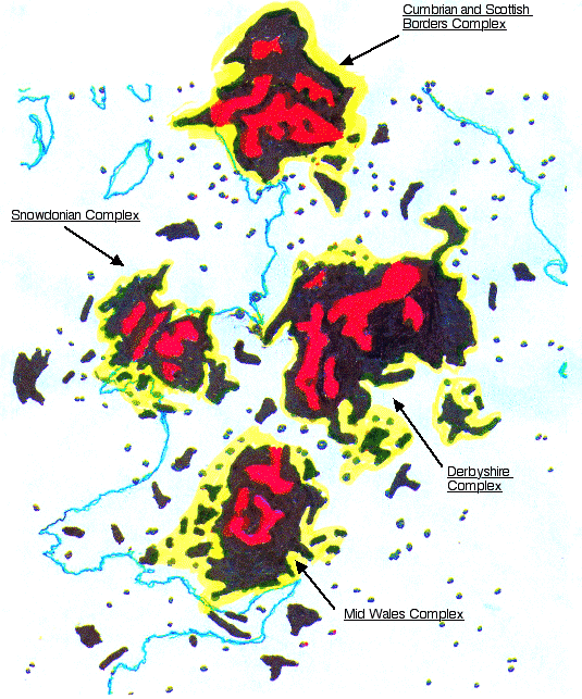 Fig 11 REPRESENTATION OF CLUSTER EARTHQUAKE ZONES AND ASEISMIC GRABENS TAKEN FROM B.G.S. SUPPLIED MAPS. Red zones Aseismic Grabens. | |||||
|
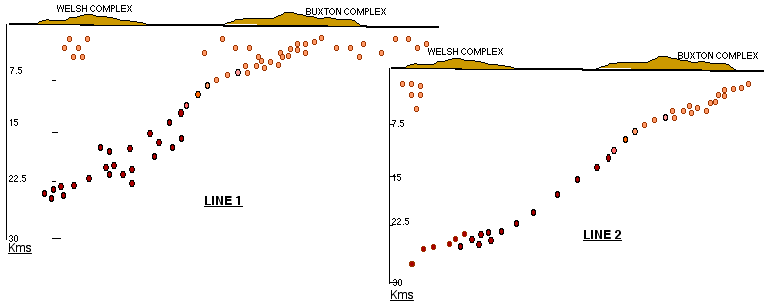
| It is very noticeable that the deeper earthquakes are in the main clustered under the Welsh Complex. Where the shallower earthquakes are clustered under the Buxton Complex. The lighter coloured earthquakes are the shallower ones, whereas the Deeper ones are indicated by the deeper colours. | ||||
| The deeper earthquakes under the Welsh Complex probably indicate more dense material at depth with a much deeper magmatic level beneath this denser solidified material. For the Buxton Complex it more than likely suggests the magmatic material at a much shallower depth. This seems to be true for the Cumbrian Complex as well. A less defined area in the Snowdonian Complex is indicated. So at this showing it looks as though the Buxton Complex and the Cumbrian one would be the ones to concentrate on, with a survey carried out in the aseismic zones. Surface to magma level appears to be much greater under the Welsh Complex, and shallower under the Buxton Complex. It will also be shallower under the Cumbrian Complex. | |||||
|
| |||||
| |||||